Server Status
The Server Status page shows you many metainformation about the current GeoServer configuration and overall status.
It provides a useful diagnostic tool in a testing and production environment and should be your first place to go if are facing any problem with your running GeoServer instance.
Certainly it's always useful to have a look at the Logs additionally.
Status indicators
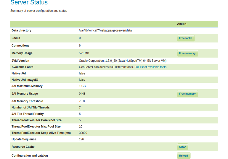
The following table describes the current status indicators (as described here).
| Option | Description |
|---|---|
| Data directory | The absolute path to your data directory. |
| Locks | A WFS has the ability to lock features to prevent more than one person from updating the feature at one time. If data is locked, edits can be performed by a single WFS editor. When the edits are posted, the locks are released and features can be edited by other WFS editors. A zero in the locks field means all locks are released. If locks is non-zero, then pressing Free locks releases all feature locks currently held by the server, and updates the field value to zero. |
| Connections | Refers to the numbers of vector stores, in the above case 6, that were able to connect. |
| Memory Usage | The amount of memory currently used by GeoServer. Clicking on the Free Memory button, cleans up memory marked for deletion by running the garbage collector. |
| JVM Version | Denotes which version of the JVM (Java Virtual Machine) is been used to power the server. |
| Available Fonts | A list of all fonts GeoServer has access to. These can be referenced in the layer style. |
| Native JAI | GeoServer uses Java Advanced Imaging (JAI) framework for image rendering and coverage manipulation. When properly installed (true), JAI makes WCS and WMS performance faster and more efficient. |
| Native JAI ImageIO | GeoServer uses JAI Image IO (JAI) framework for raster data loading and image encoding. When properly installed (true), JAI Image I/O makes WCS and WMS performance faster and more efficient. |
| JAI Maximum Memory | Expresses in bytes the amount of memory available for tile cache. |
| JAI Memory Usage | Run-time amount of memory is used for the tile cache. Clicking on the Free Memory button, clears available JAI memory by running the tile cache flushing. |
| JAI Memory Threshold | Refers to the percentage, e.g. 75, of cache memory to retain during tile removal. JAI Memory Threshold value must be between 0.0 and 100. |
| Number of JAI Tile Threads | The number of parallel threads used by to scheduler to handle tiles. |
| JAI Tile Thread Priority | Schedules the global tile scheduler priority. The priority value is defaults to 5, and must fall between 1 and 10. |
| ThreadPoolExecutor Core Pool Size | The imageMosaic reader may load, in parallel, different files that make up the mosaic by means of a ThreadPoolExecutor. A global ThreadPoolExecutor instance is shared by all the readers supporting and using concurrent reads. Here the current core pool size of the ThreadPoolExecutor is listed. |
| ThreadPoolExecutor Max Pool Size | Here the current maximum core pool size of the ThreadPoolExecutor is listed. |
| ThreadPoolExecutor Keep Alive Time (ms) | The time to be waited by the ThreadPoolExecutor before terminating an idle thread in case there are more threads than available in the core pool size. |
| Update Sequence | Refers to the number of times the server configuration has been modified. |
| Resource Cache | GeoServer does not cache data, but it does cache connection to stores, feature type definitions, external graphics, font definitions and CRS definitions as well. The Clear button forces those caches to empty and makes GeoServer reopen the stores and re-read image and font information, as well as the custom CRS definitions stored in ${GEOSERVER_DATA_DIR}/user_projections/epsg.properties. |
| Configuration and catalog | GeoServer keeps in memory all of its configuration data. If for any reason that configuration information has become stale (e.g. an external utility has modified the configuration on disk) the Reload button will force GeoServer to reload all of its configuration from disk. |
Exercise
- Open up the
Server Statuspage on your GeoServer and press the buttonFree memorybesidesMemory Usage. What do you observe?