Vector Layers
Vector Layers are represented by ol.layer.Vector and handle the client-side display of vector data. Currently OpenLayers 3 supports full vector rendering in the Canvas renderer, but only point geometries in the WebGL renderer.
Rendering Features Client-Side
Let's go back to the WMS example to get a basic world map. We'll add some feature data on top of this in a vector layer.
<!doctype html>
<html lang="en">
  <head>
    <link rel="stylesheet" href="/ol.css" type="text/css">
    <style>
      #map {
        height: 256px;
        width: 512px;
      }
    </style>
    <title>OpenLayers 3 example</title>
    <script src="/loader.js" type="text/javascript"></script>
  </head>
  <body>
    <h1>My Map</h1>
    <div id="map"></div>
    <script type="text/javascript">
      var map = new ol.Map({
        target: 'map',
        layers: [
          new ol.layer.Tile({
            title: 'Global Imagery',
            source: new ol.source.TileWMS({
              url: 'http://demo.opengeo.org/geoserver/wms',
              params: {LAYERS: 'nasa:bluemarble', VERSION: '1.1.1'}
            })
          })
        ],
        view: new ol.View({
          projection: 'EPSG:4326',
          center: [0, 0],
          zoom: 0,
          maxResolution: 0.703125
        })
      });
    </script>
  </body>
</html>
Tasks
- Open
map.htmlin your text editor and copy in the contents of the initial WMS example. Save your changes and confirm that things look good in your browser: http://terrestris.github.io/momo3-ws//map.html In your map initialization code add another layer after the Tile layer (paste the following). This adds a new vector layer to your map that requests a set of features stored in GeoJSON:
 new ol.layer.Vector({
    title: 'Earthquakes',
    source: new ol.source.Vector({
      url: '/data/layers/7day-M2.5.json',
      format: new ol.format.GeoJSON()
    }),
    style: new ol.style.Style({
      image: new ol.style.Circle({
        radius: 3,
        fill: new ol.style.Fill({color: 'white'})
      })
    })
  })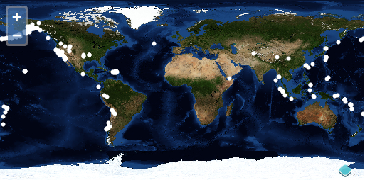
A Closer Look
Let's examine that vector layer creation to get an idea of what is going on.
new ol.layer.Vector({
  title: 'Earthquakes',
  source: new ol.source.Vector({
    url: '/data/layers/7day-M2.5.json',
    format: new ol.format.GeoJSON()
  }),
  style: new ol.style.Style({
    image: new ol.style.Circle({
      radius: 3,
      fill: new ol.style.Fill({color: 'white'})
    })
  })
})
The layer is given the title 'Earthquakes' and some custom options. In the options object, we've included a source of type ol.source.Vector which points to a url. We've given the source a format that will be used for parsing the data.
Note - In the case where you want to style the features based on an attribute, you would use a style function instead of an ol.style.Style for the style config option of ol.layer.Vector.
Bonus Tasks
- The white circles on the map represent
ol.Featureobjects on yourol.layer.Vectorlayer. Each of these features has attribute data withtitleandsummaryproperties. Register a'singleclick'listener on your map that callsforEachFeatureAtPixelon the map, and displays earthquake information below the map viewport. - The data for the vector layer comes from an earthquake feed published by the USGS (http://earthquake.usgs.gov/earthquakes/catalogs/). See if you can find additional data with spatial information in a format supported by OpenLayers 3. If you save another document representing spatial data in your
datadirectory, you should be able to view it in a vector layer on your map.
Solutions
As a solution to the first bonus task you can add an info div below the map:
<div id="info"></div>
and add the following JavaScript code to display the title of the clicked feature:
map.on('singleclick', function(e) {
  var feature = map.forEachFeatureAtPixel(e.pixel, function(feature) {
    return feature;
  });
  var infoElement = document.getElementById('info');
  infoElement.innerHTML = feature ? feature.get('title') : '';
});