Style
A style is a visualization directive for rendering geographic data. A style can contain rules for color, shape, and size, along with logic for styling certain features or points in certain ways based on attributes or scale level.
Every layer must be associated with at least one style. GeoServer recognizes styles in Styled Layer Descriptor (SLD) format. The Styling section will go into this topic in greater detail.
Create and assign a style to a layer
- Go to
Data❭Styles❭Add a new style - Create a new style as follows:
- Name: countries
- Workspace: momo
- Format: SLD
- Copy and paste the following SLD content into the style field:
  <?xml version="1.0" encoding="UTF-8"?>
  <sld:StyledLayerDescriptor
  xmlns="http://www.opengis.net/sld"
  xmlns:sld="http://www.opengis.net/sld"
  xmlns:ogc="http://www.opengis.net/ogc"
  xmlns:gml="http://www.opengis.net/gml"
  version="1.0.0">
  <sld:NamedLayer>
    <sld:Name>countries</sld:Name>
    <sld:UserStyle>
        <sld:Name>Countries</sld:Name>
        <sld:Title>Countries</sld:Title>
        <sld:FeatureTypeStyle>
            <sld:Name>countries</sld:Name>
            <sld:Rule>
                <sld:PolygonSymbolizer>
                    <sld:Fill>
                        <sld:CssParameter name="fill">#EDEDED</sld:CssParameter>
                    </sld:Fill>
                    <sld:Stroke>
                        <sld:CssParameter name="stroke">#969696</sld:CssParameter>
                        <sld:CssParameter name="stroke-width">0.5</sld:CssParameter>
                    </sld:Stroke>
                </sld:PolygonSymbolizer>
                <sld:TextSymbolizer>
                    <sld:Label>
                        <ogc:PropertyName>name</ogc:PropertyName>
                    </sld:Label>
                    <sld:Font>
                        <CssParameter name="font-family">DejaVu Sans</CssParameter>
                        <CssParameter name="font-size">10</CssParameter>
                    </sld:Font>
                    <sld:LabelPlacement>
                        <sld:PointPlacement>
                            <sld:AnchorPoint>
                                <sld:AnchorPointX>0.5</sld:AnchorPointX>
                                <sld:AnchorPointY>0.5</sld:AnchorPointY>
                            </sld:AnchorPoint>
                        </sld:PointPlacement>
                    </sld:LabelPlacement>
                    <sld:Halo>
                        <sld:Radius>1</sld:Radius>
                        <sld:Fill>
                            <CssParameter name="fill">#FFFFFF</CssParameter>
                        </sld:Fill>
                    </sld:Halo>
                    <sld:Fill>
                        <CssParameter name="fill">#707070</CssParameter>
                    </sld:Fill>
                </sld:TextSymbolizer>
            </sld:Rule>
        </sld:FeatureTypeStyle>
    </sld:UserStyle>
  </sld:NamedLayer>
  </sld:StyledLayerDescriptor>
- Go to
Data❭Layers, search forcountriesand select it in the list.
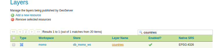
- Go to tab
Publishing.

- Select
momo:countriesin dropdown listDefault Style.

- Click
Save. - Open the layer preview for the layer
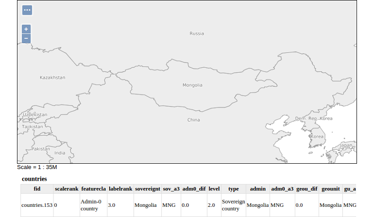
countriesand you will see that the layer will have a new appearance (light grey polygon fill) including labels for each country.